/
Depression in Bay of Bengal may become Cyclone Akvan, third after Murasu
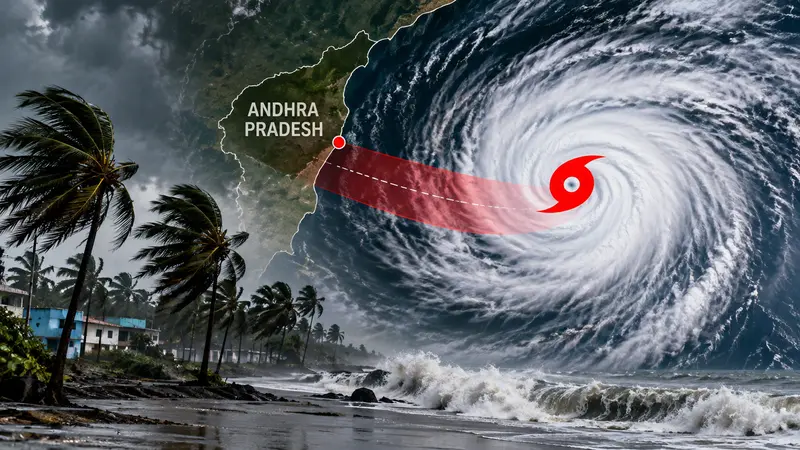
The IMD says a depression over the Bay of Bengal is likely to become Cyclone Akvan by the evening of 16 November, with landfall forecast near North Coastal Andhra Pradesh around 19-20 November.
R
5 min
The India Meteorological Department (IMD) said on 15 November that a depression has formed over the Bay of Bengal and is forecast to strengthen into a cyclonic storm. If it does, it will be the third such storm to threaten India's east coast after Cyclones Arnab and Murasu.
The department placed the depression about 700 km west-southwest of Port Blair, 860 km east-southeast of Chennai and 1,040 km south-southeast of Visakhapatnam. Earlier it was a well-marked low-pressure area spread over the southeast and southwest Bay of Bengal, and it has now moved up a stage.
The weather system is likely to become Cyclone Akvan by the evening of 16 November. It is still far offshore, hundreds of kilometres from the nearest of those three reference points, and no landfall has taken place.
Coastal authorities are nonetheless already preparing. Andhra Pradesh is bracing for a third cyclone this month, and an Odisha minister has said the state is ready with its personnel and its disaster mitigation machinery for what would be a third cyclone in three weeks.
The track the IMD has set out
The IMD's outlook for 16 and 17 November has the depression moving north-northwestwards. Along that path it is expected to intensify into a Cyclonic Storm and then into a Severe Cyclonic Storm over the westcentral Bay of Bengal. After reaching that strength, it is projected to move toward the Andhra Pradesh coast.
The progression is laid out in stages, and each one is a step up in strength. A well-marked low-pressure area has already become a depression. The next two steps, to Cyclonic Storm and then Severe Cyclonic Storm, are the ones the department expects over the two days ahead, with the westcentral Bay of Bengal named as the area where the strongest phase is forecast.
The distances given on 15 November also show where the depression sits relative to the coast. It is 860 km from Chennai and 1,040 km from Visakhapatnam, which makes it about 180 km closer to the Tamil Nadu capital than to the port city on the Andhra coast. Its heading, though, is north-northwest, and that points it toward Andhra Pradesh rather than toward Chennai.
The IMD's forecast for landfall is near North Coastal Andhra Pradesh around 19 and 20 November, with winds increasing along the coast as the storm approaches. The department's regional specialised meteorological centre in New Delhi carries the full tracking updates and official bulletins on the depression.
Those bulletins are the reference for anyone following the storm. They give the position, the distance from the main coastal cities and the expected stage of intensification, and they are revised as the weather system moves.
Andhra Pradesh sits directly in the path the IMD has described. The forecast of landfall near its northern coastal belt on 19 or 20 November has put the state on alert for a third cyclonic storm within the month, following Arnab and Murasu. Winds are forecast to rise as the storm closes in.
Odisha, further up the coast, has also moved to show it is ready. The state minister who spoke on the matter said Odisha has its personnel and its disaster mitigation machinery in place as a possible third cyclone in three weeks forms over the Bay of Bengal. The remarks did not include numbers for staff, shelters or evacuations.
The word "possible" in the minister's remarks reflects the stage the storm has reached. A depression is not yet a cyclone, and the IMD's own forecast has it passing through two more categories before any crossing. Odisha's readiness is therefore a precaution taken ahead of the forecast, and not a response to a storm that has already arrived.
The sequence of storms is itself the reason for the attention. Arnab came first and Murasu followed. The new depression has formed within weeks, and it is described as the third cyclone in about a month. Coastal districts that have dealt with two warnings in that time now face a third, with the forecast pointing at the same stretch of the east coast.
No casualty figures, evacuation numbers or damage assessments have been reported for the new depression, since it remains well out at sea. Those figures will matter only if and when the storm nears land, and the IMD's timetable puts that around 19 and 20 November.
Forecast models do not agree
Where the storm will come ashore is the least settled part of the picture. Weather models have diverged on the landfall location, even as the IMD points to North Coastal Andhra Pradesh. Some models suggest a movement toward north Andhra Pradesh, which fits the department's outlook, but the spread between them leaves the exact crossing point uncertain.
That uncertainty carries over to the neighbouring states. With the models split, Odisha's preparations make sense alongside Andhra Pradesh's, since a track that bends even slightly could change which stretch of coast takes the heaviest winds. The IMD has not changed its stated landfall area, and the divergence is a question about detail, not about the broad direction.
How strong the storm is when it nears land will depend on how it develops over the westcentral Bay of Bengal on 16 and 17 November. The department has said it is expected to reach Severe Cyclonic Storm strength there. That is the highest category in its forecast so far, and it comes before the move toward the Andhra Pradesh coast.
The next marker is the evening of 16 November, when the low-pressure area is likely to become Cyclone Akvan. The IMD's bulletins on 16 and 17 November will show whether the depression reaches Cyclonic Storm strength on schedule and whether the north-northwest track still leads to the Andhra Pradesh coast. The landfall window the department has given runs to 19 and 20 November.
About the Author
R
Reyaansh Agarawal
Staff Writer
Reyaansh Agarawal contributes to Wirony, covering stories that are carefully reviewed and approved by the editorial team before publication. Wirony is committed to maintaining tran…
R
5 min
What did you think?